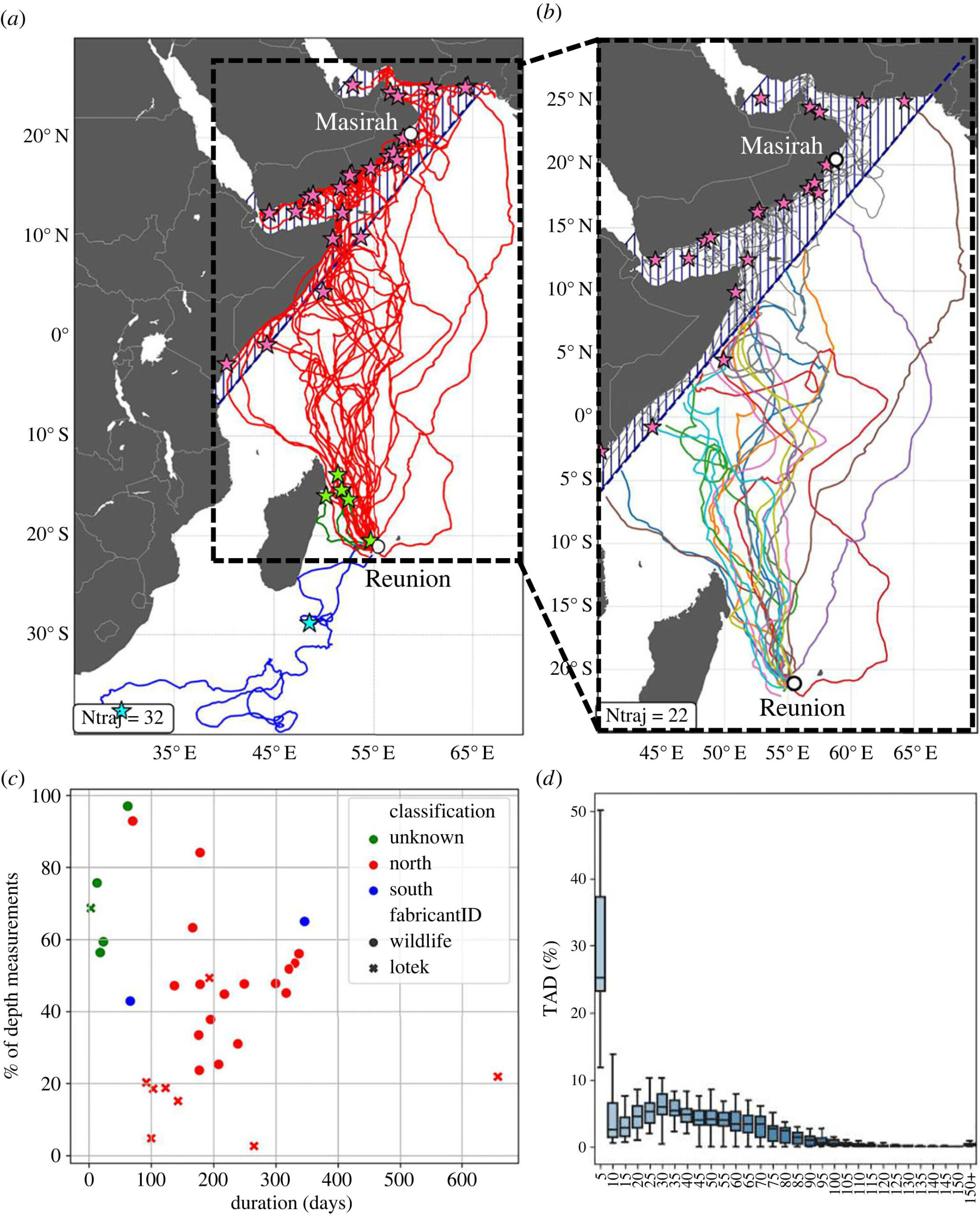
 Satellite tracks of the 32 late-juvenile loggerhead turtles released from Reunion Island between 2019 and 2022. Tracks are grouped into three categories: North (red), South (blue) and Unknown (green) based on their last recorded position (respectively, red, blue, and green stars). (b) Tracks of the 25 animals migrating north (group North) used in this study with their last recorded position (red stars). The blue dashed area in (a) and (b) indicates where all individuals from group North were considered to have ended the open-ocean portion of their track. (c) Relationship between tag life duration and the average percentage of depth measurements recovered for all 32 tracks classified by group (color) and by tag manufacturer (dots for WC, crosses for LOTEK). (d) Inter-individual time-at-depth (TAD) distribution for the open-ocean transect of group North turtles (N = 25). Credit: Journal of The Royal Society Interface (2023). DOI: 10.1098/rsif.2023.0383")
A study published in the Journal of The Royal Society Interface has revealed new insights into the navigational strategies of sea turtles during their pre-reproductive migration.
Using data from 25 juvenile loggerhead turtles, researchers have uncovered a remarkable map and compass strategy not previously seen in this turtle species.
This novel strategy involves straight-line swimming at a steady speed of about 0.5 meters per second, interspersed with occasional course corrections.
What makes this discovery even more significant is the methodology used: The researchers considered three-dimensional ocean currents, rather than the more commonly used surface current approach.
This novel approach reveals a common, cross-species, open-ocean navigation mechanism and highlights the crucial role of diving behavior in understanding the spatial ecology of sea turtles.
Sea turtles navigate oceans using their internal map-and-compass orienteering abilities.
Combining tracking data from 25 late-juvenile loggerhead turtles migrating from Reunion Island in the Pacific Ocean with 3D models of ocean currents, researchers have mapped for the first time how the turtles combine straight-line swimming with occasional course corrections to account for ocean currents.
This strategy, hypothesized in green and hawksbill turtles, may be a common ocean-navigation mechanism across all turtle species.
More information:
Antoine Laforge et al, Uncovering loggerhead ( Caretta caretta ) navigation strategy in the open ocean through the consideration of their diving behaviour, Journal of The Royal Society Interface (2023). DOI: 10.1098/rsif.2023.0383
Provided by
The Royal Society
Citation:
Tagged turtles and 3D ocean current maps reveal loggerheads’ navigation mechanisms (2023, December 13)
retrieved 13 December 2023
from https://phys.org/news/2023-12-tagged-turtles-3d-ocean-current.html
This document is subject to copyright. Apart from any fair dealing for the purpose of private study or research, no
part may be reproduced without the written permission. The content is provided for information purposes only.